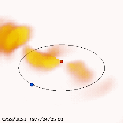
The image depicting the heliosphere on April 05, 1977 at 00 UT, the
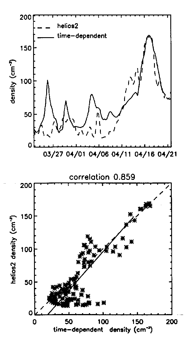
model correlation with Helios 2 in-situ density at the spacecraft and a
1.9 Mbyte *.avi video presentation that
includes the above image as one of the time sequence steps is a reconstruction
of heliospheric plasma density (extrapolated to heights as great as 3.0 times
the distance of the Earth from the Sun) derived from a combination of Helios
photometer observations and UCSD interplanetary scintillation (IPS) velocity
observations. This "time-dependent" tomographic modeling technique
maps day to day changes in the solar wind density content in three dimensions
over the heliosphere.
The Helios photometer Thomson-scattering brightness observations
map density and are least squares fit to a time-dependent kinematic model using
time steps of one day. These short time steps restrict the data fits so that
outward plasma motion alone is used to deconvolve the 3-D structures.
The data for
the video were obtained from Carrington Rotation 1653 (March 24 00 UT to April 20,
00 UT 1977. The spatial resolution is approximately 10 by 10
degrees in heliographic latitude and longitude and 0.25 AU (Earth to Sun) in solar
distance. Higher density features are more yellow and more opaque. The Sun is depicted
as a dot in the center of the image, and the Earth, a blue dot
on its orbit around the Sun. The view is from 30 degrees above the ecliptic plane
from a position about 45 degrees west of the Sun-Earth line at a distance of 3 AU.
The video sequence presents each day's tomographic model result
with a cadence of one-quarter day between frames over the time interval. Densities
throughout the whole of the Carrington rotation time interval correlate to in-situ
densities at the Helios 2 with a CCF of ~0.86 (see figure).
During Carrington Rotation 1653 Helios 1 moved from 0.52 AU 25 degrees east of the
Sun-Earth line to 0.34 AU 88 degrees west. Helios 2 moved from 0.64 AU 12 degrees
east to 0.30 AU 57 degrees west, and thus both spacecraft were near one another and
near Earth. This is the same data set that was used provide input for the kinematic
corotating model fit
(see 3-D White-light Tomography.)
The tomographic model fit to brightness has a far more simple relationship with
density than does IPS g-level
with density (see
"Time-Dependent" Cambridge/STELab Tomography)
accessed in current
Space Weather Forecasts.
The time period shown in 1977 is during the ascending phase of solar activity cycle 21.
There are several large Coronal Mass Ejections (CMEs) shown in the data, but most of
the sustained activity (highlighted in the still image) can be shown to arise from above
the northern hemisphere active region 701 throughout Carrington Rotation 1653.
The
heliospheric data fit shows the extent that so-called corotating heliospheric regions
maintain their integrity throughout a one-month time period. More information about
these corotating features observed in the Helios photometer data can be found in:
Jackson, B.V.: 1991, "Helios Spacecraft Photometer Observations of Elongated Corotating
Structures in the Interplanetary Medium", J. Geophys. Res., 96, 11,307. More
details of the tomography using the Helios Photometer data can be found in:
Jackson, B.V. and P. Hick: 2000, "Three Dimensional Tomography of Heliospheric Features
Using Global Thomson Scattering Data", Adv. Space Res.,
25, No. 9, 1875.
An additional video sequence of during the May, 1979 activity maximum can be found
at:
Time-Dependent Tomography Using Helios 2 Photometer Data.
|
|